


Hurricane Simon strengthened to a Category 1 storm Tuesday and is expected to reintensify to Category 2 overnight, and its slow, uncertain track puts nearly all of Baja California Sur in the watch zone this week. Forecasters say the system could pass within 31 kilometers (about 19 miles) of La Paz by Saturday, but the broader circulation is already bringing rain, rough surf and shifting alerts from Los Cabos up through the Gulf of California.
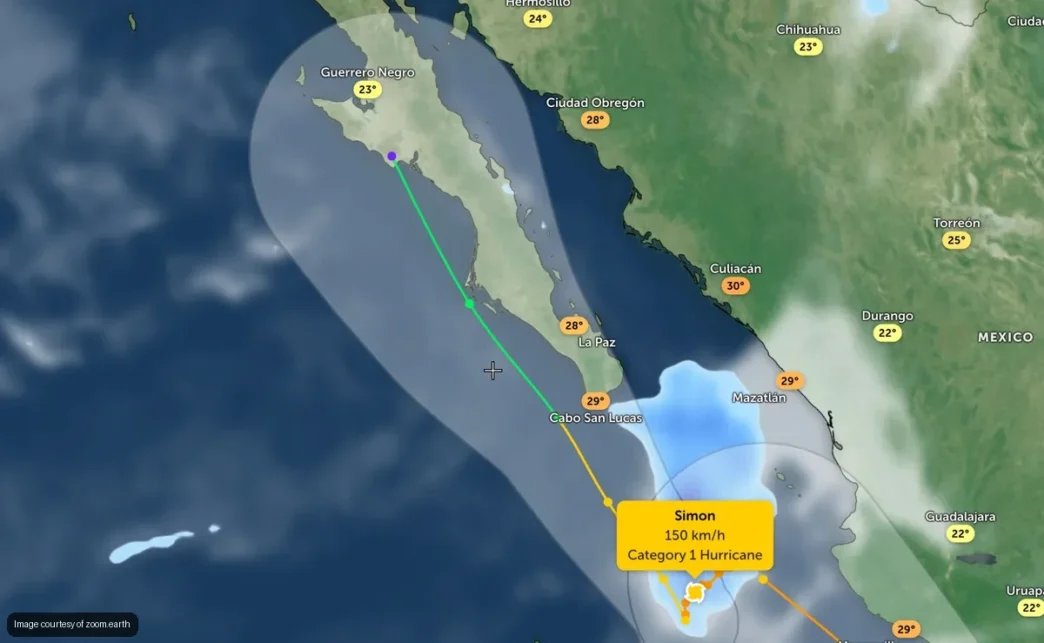
As of Tuesday afternoon, Simon was packing maximum sustained winds near 150 km/h (93 mph), with gusts up to 185 km/h (115 mph), and sitting roughly 382 kilometers (237 miles) southeast of Los Cabos, according to El Sudcaliforniano. Mexico’s National Water Commission, known as Conagua, expects the storm to keep intensifying over the next 24 hours before stalling nearly in place off the coast for about two days and then curving north.
Ports and Boats Brace Across the State
The Capitanía de Puerto Regional, the regional port authority, closed the Port of La Paz to small vessels starting at 8 p.m. Tuesday, Oct. 13, as a precaution. Whether larger commercial and cruise traffic faces restrictions elsewhere in Baja California Sur will depend on how the storm behaves over the next few days.
Boat owners anchored in La Paz Bay are being told to move vessels into a marina or a more sheltered port rather than ride out the storm at anchor. Strong winds and swell can snap anchor lines and set boats adrift — the same concern that led to six sailboats being left stranded in La Paz Bay after a strong wind event earlier this year.
Simon’s Path Across Baja California Sur
The forecast track shows Simon reintensifying to Category 2 or possibly Category 3 strength within a day or so, then crawling slowly before curving toward the Gulf of California — a path that keeps the entire southern peninsula, from Los Cabos to the capital, inside the margin of error. By Friday, Oct. 16, the storm’s center is projected to sit about 230 kilometers (143 miles) from La Paz, still a hurricane with winds near 130 km/h (81 mph).
By 11 a.m. Saturday, Oct. 17, the U.S. National Hurricane Center’s track puts the center roughly 31 kilometers from La Paz, by then weakened to a tropical storm with winds around 80 km/h (50 mph). Forecasters caution that the projected line doesn’t guarantee the storm follows it exactly, nor does it pin down how much wind or rain any single community in Baja California Sur will see. By Sunday, Oct. 18, Simon is expected to lose its tropical characteristics as it moves inland.
Rain, Surf and Coastal Impacts From Los Cabos to La Paz
Baja California Sur’s Protección Civil, the state civil protection agency, expects rainfall totals of 25 to 50 millimeters (1 to 2 inches) statewide, with isolated pockets up to 75 millimeters (3 inches). Some regional forecasts tied to the storm’s broader circulation have floated higher totals along the Pacific coast and the Gulf of California entrance, which puts low-lying areas and arroyos across the state at risk — a pattern familiar to anyone who remembers the flash flooding that hit La Paz in a previous storm.
Coastal waters from Los Cabos to La Paz should see elevated surf and dangerous rip currents through the week, even where rain stays light. Officials have not yet confirmed any beach or port closures for Los Cabos or Cabo San Lucas, though that could change quickly given the storm’s proximity — a scenario similar to the restrictions ordered ahead of Hurricane Rachel just weeks earlier this season.
What to Watch This Week Across Baja California Sur
Airlines had not announced flight disruptions for Los Cabos International Airport or La Paz as of Tuesday, but anyone with weekend travel plans should check directly with their airline given how close Simon’s projected path runs to the peninsula. Boaters, fishermen and anyone with plans on the water from the East Cape to La Paz should watch for updates from the Capitanía and Protección Civil, both of which say they will activate emergency protocols if conditions warrant it.
The bottom line: Simon’s track still carries real uncertainty several days out, and a shift of even a few dozen kilometers could mean the difference between a rainy weekend across Baja California Sur and a direct brush with tropical-storm-force winds. Residents and visitors from Los Cabos to La Paz should keep monitoring official updates through the weekend rather than relying on early forecast maps.
