


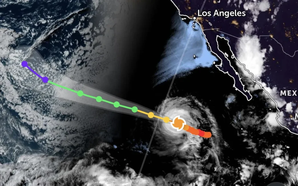
Hurricane Genevieve has been downgraded to Category 2 as it continues moving west-northwest across the Pacific, roughly 1,135 kilometers west of Baja California Sur. The storm, which once reached major hurricane status, now carries sustained winds of 155 km/h with gusts reaching 195 km/h, according to Mexico’s National Meteorological Service.
Although the hurricane poses no direct threat to Mexican communities, its outer cloud bands are still generating heavy rainfall and strong swells along portions of the Pacific coast.
What to Expect Over the Next 48 Hours
Genevieve is moving away from the coast at about 15 km/h and is expected to weaken further as it encounters cooler sea surface temperatures and drier air. Forecasters anticipate the storm will drop to Category 1 status by early Thursday, with sustained winds falling to 140 km/h or less.
Despite the downgrade, the system remains large and well-organized. Strong convection continues near the center, and upper-level outflow remains well-defined. However, there is no visible eye on satellite imagery, and the cyclone is expected to continue losing strength throughout the forecast period.
Los Cabos ports were closed earlier as a precautionary measure while Genevieve was still intensifying, but the storm has since tracked farther offshore and away from populated areas.
Rainfall and Coastal Impacts Across Mexico
While Genevieve is moving away from land, its moisture-laden outer bands are still fueling heavy rainfall across several states. Chiapas and Tabasco are forecast to receive the most intense rain, while Sonora, Chihuahua, Oaxaca, and Veracruz can expect strong to very strong downpours with isolated thunderstorms.
States along the western and central regions — including Durango, Sinaloa, Nayarit, Jalisco, Guerrero, Puebla, Campeche, and Yucatán — will see scattered showers with locally heavy bursts. Mexico City, Quintana Roo, and Baja California Sur should prepare for intermittent showers throughout the day.
In addition to rainfall, high waves and strong swells continue to affect the western coast of the Baja California peninsula, with wave heights reaching 1.5 to 2.5 meters. Mariners and beachgoers are advised to exercise caution.
Hazards Beyond the Storm Center
Even as Genevieve weakens, it remains a dangerous system. Possible hazards include damaging winds in offshore areas, heavy rainfall leading to flash flooding and mudslides, storm surge in isolated coastal zones, and rough seas that make navigation risky.
The National Hurricane Center warns that the cyclone will likely degenerate into a post-tropical system by the weekend as deep convection diminishes. However, until that transition occurs, coastal residents and visitors should stay informed through official channels and avoid unnecessary exposure to coastal conditions.
Looking Ahead
Genevieve is forecast to continue moving west-northwest over the next several days, steered by a strong mid-level high-pressure system stretching from the southwestern United States into the eastern Pacific. A gradual increase in forward speed is expected as the ridge builds westward.
By late in the forecast period, a trough near 145°W should induce a turn to the right, pulling the storm farther from the Mexican mainland. As sea surface temperatures cool and vertical wind shear increases, Genevieve will continue to weaken.
Residents and tourists in Baja California Sur and along the Pacific coast should monitor updates closely, even as the immediate threat recedes. Coastal swells, rainfall, and gusty winds are expected to linger for another day or two before conditions improve.