


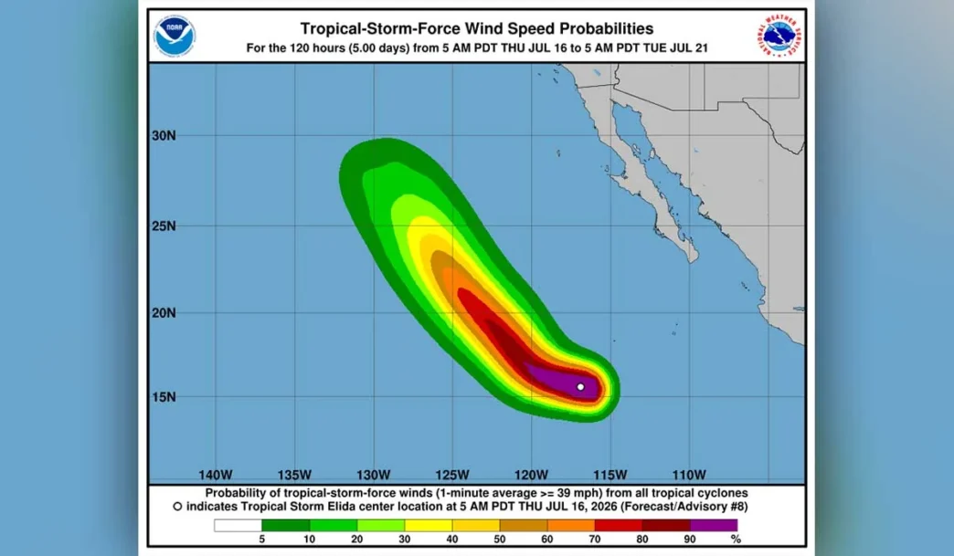
Tropical Depression Five-E officially strengthened into Tropical Storm Elida early Wednesday morning, marking the fifth named storm of the Pacific hurricane season. Although forecasters expect Elida to intensify into a Category 2 hurricane by Friday, the system is moving away from the Mexican coast and poses no direct threat to Baja California Sur.
According to the Servicio Meteorológico Nacional, Elida’s center was located approximately 910 kilometers south-southwest of Cabo San Lucas at 2:00 a.m. Wednesday, with maximum sustained winds of 65 kilometers per hour and gusts reaching 85 km/h. The storm is moving west at 24 km/h and is expected to continue on that trajectory, moving further into open Pacific waters.
What BCS Residents Should Expect
While the storm itself will not make landfall, its outer cloud bands will bring indirect effects to the peninsula. The National Weather Service is forecasting scattered showers producing 5 to 25 millimeters of rainfall across various parts of Baja California Sur, accompanied by electrical storms.
Wind gusts of 40 to 60 kilometers per hour are expected, along with elevated surf of one to two meters along the Pacific coast. These conditions could affect fishing and small-craft operations, and authorities are advising mariners to take appropriate precautions.
Francisco Cota Márquez, director of Los Cabos Municipal Civil Protection and Risk Management, told local outlets that his office is maintaining permanent monitoring of meteorological conditions but emphasized that Elida does not represent a risk to the state. Officials will continue tracking the storm’s evolution and will inform the public immediately if any changes in trajectory or intensity occur.
Storm Forecast and Trajectory
Meteorological models analyzed by the BCS Civil Protection Subsecretariat agree that Elida will continue moving into open waters of the Pacific Ocean, progressively distancing itself from Mexican shores. The storm is expected to reach hurricane status Thursday night and could intensify to Category 2 on the Saffir-Simpson scale by Friday before beginning a gradual weakening over the weekend.
The projected track shows consistent westward and then west-northwest movement, with no indications of significant approach to the Mexican coastline. For those familiar with past tropical storm patterns in the region, Elida’s behavior is following a common offshore trajectory that keeps the most dangerous conditions well away from populated areas.
Weather Outlook for Los Cabos
Wednesday’s forecast for Los Cabos calls for partly to mostly cloudy skies with isolated showers and wind gusts up to 60 kilometers per hour. Temperatures across Baja California Sur are expected to range between 35 and 40 degrees Celsius through the week, typical for mid-July.
Given the combination of high heat and potential rain, Civil Protection authorities are recommending residents and visitors stay hydrated, avoid prolonged sun exposure between 11:00 a.m. and 4:00 p.m., wear light-colored clothing, and pay special attention to children, seniors, and those with chronic health conditions.
As hurricane season continues, officials are reminding the public to stay informed only through official channels and to report any weather-related concerns to local emergency services.