


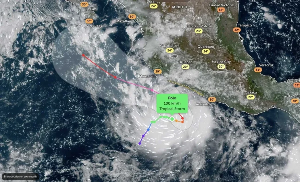
Tropical Storm Polo is churning off Mexico’s Pacific coast and could strengthen into a major hurricane over the next few days, according to forecasts from the National Hurricane Center and AccuWeather. While the system is expected to parallel the coastline, residents of Baja California Sur should prepare for dangerous surf conditions and gusty winds over the next several days.
As of Saturday morning, Polo was located roughly 200 miles southwest of Zihuatanejo, Guerrero, with sustained winds of 62 mph and higher gusts. The storm formed late Sunday evening from a tropical depression that had been monitored since mid-September.
What to Expect in Baja California Sur
Although Polo’s projected path keeps the center of circulation well offshore and aimed more directly at the states of Jalisco, Colima, Michoacán, and Guerrero, coastal areas of southern Baja will still feel indirect effects. Forecasters warn of elevated surf, dangerous rip currents, and moderate winds as the system intensifies.
Swells generated by the storm could produce waves up to 13 feet along Baja’s southern Pacific shores. Beachgoers and boaters should avoid the water until conditions improve. Winds across the region may gust to 40 mph at times, particularly along exposed coastal zones.
Mexican meteorologists note that rainfall in Baja California Sur is expected to remain light to moderate, with isolated heavier totals possible in mountainous areas. Most forecast models keep the heaviest precipitation concentrated farther south along the mainland coast.
Rapid Intensification Expected
Polo is forecast to undergo rapid intensification as it moves over warm Pacific waters. AccuWeather meteorologists predict the storm could reach Category 1 status by Tuesday and potentially become a major hurricane later in the week. Rapid intensification occurs when a tropical cyclone’s maximum sustained winds increase by at least 35 mph within 24 hours.
“Polo has the potential to rapidly intensify into a powerful hurricane,” said AccuWeather meteorologist Alex Duffus. The storm’s projected northeastward movement followed by a northwest turn will keep it parallel to the coast, reducing the likelihood of a direct landfall but maintaining threats from storm surge, wind, and rain along exposed mainland coastlines.
What Residents Should Know
Protección Civil in Baja California Sur has not issued evacuation orders, but authorities encourage residents to monitor updates closely. Those living in low-lying coastal areas or near arroyos should be prepared to move to higher ground if conditions deteriorate or heavy rain arrives unexpectedly.
Visitors planning beach activities over the next week should check surf forecasts daily and obey any red flags posted at beaches. Even distant storms can generate deadly rip currents along Baja shores.
Mariners are advised to secure vessels and avoid heading offshore until the storm moves well past the region. The Capitanía de Puerto may issue additional advisories as conditions evolve.
Looking Ahead
Polo is the fifteenth named storm of the 2026 Eastern Pacific hurricane season. While Baja California Sur has largely been spared direct impacts this year, the storm serves as a reminder that the hurricane season runs through November and conditions can change rapidly.
Residents should review emergency supplies, ensure drainage systems around homes are clear, and keep an eye on official weather updates from the Servicio Meteorológico Nacional and local civil protection authorities.
